Installeer de app
Hoe installeer je de app op iOS
Volg de onderstaande video om te zien hoe je onze site als web-app op je startscherm installeert.
Opmerking: Deze functie is mogelijk niet beschikbaar in sommige browsers.
Je gebruikt een verouderde webbrowser. Het kan mogelijk deze of andere websites niet correct weergeven.
Het is raadzaam om je webbrowser te upgraden of een browser zoals Microsoft Edge of Google Chrome te gebruiken.
Het is raadzaam om je webbrowser te upgraden of een browser zoals Microsoft Edge of Google Chrome te gebruiken.
Archief - Orkanen
Het archief is een bevroren moment uit een vorige versie van dit forum, met andere regels en andere bazen. Deze posts weerspiegelen op geen enkele manier onze huidige ideeën, waarden of wereldbeelden en zijn op sommige plaatsen gecensureerd wegens ontoelaatbaar. Veel zijn in een andere tijdsgeest gemaakt, al dan niet ironisch - zoals in het ironische subforum Off-Topic - en zouden op dit moment niet meer gepost (mogen) worden. Toch bieden we dit archief nog graag aan als informatiedatabank en naslagwerk. Lees er hier meer over of start een gesprek met anderen.


KBE
Legacy Member
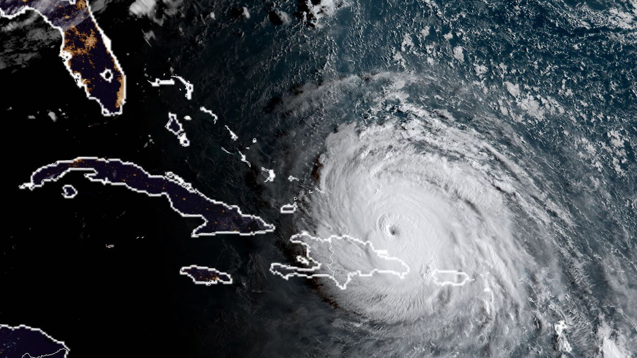
fordjah zei:De orkaan achter Irma is precies ook al duidelijk te zien op de radarbeelden?
Jose bedoel je.


bassie82
Legacy Member
Lakigigar zei:
drie op een rij
en is er nog 1 aan het vormen naar jose????


Lakigigar
Legacy Member
Irma is al meer dan 33 uur een orkaan van de hoogste categorie. Zij is daarmee de langst met deze intensiteit durende cycloon door alle weerdiensten ter wereld geregistreerd. Dat meldt Météo France.
Irma breekt het record van de supertyfoon Haiyan. Die genereerde in 2013 op de Filipijnen identieke windsnelheden (295 km per uur) maar dat slechts gedurende 24 uur.
"Een dergelijke intensiteit gedurende een zo lange tijd is in de hele wereld niet gezien sinds het begin van het satelliettijdperk een vijftigtal jaar geleden", aldus weersvoorspeller Etienne Kapikian bij de Franse weerdienst Météo France.
Lakigigar
Legacy Member
Gravetiet
Legacy Member
Lakigigar zei:Irma is al meer dan 33 uur een orkaan van de hoogste categorie. Zij is daarmee de langst met deze intensiteit durende cycloon door alle weerdiensten ter wereld geregistreerd. Dat meldt Météo France.
Irma breekt het record van de supertyfoon Haiyan. Die genereerde in 2013 op de Filipijnen identieke windsnelheden (295 km per uur) maar dat slechts gedurende 24 uur.
"Een dergelijke intensiteit gedurende een zo lange tijd is in de hele wereld niet gezien sinds het begin van het satelliettijdperk een vijftigtal jaar geleden", aldus weersvoorspeller Etienne Kapikian bij de Franse weerdienst Météo France.
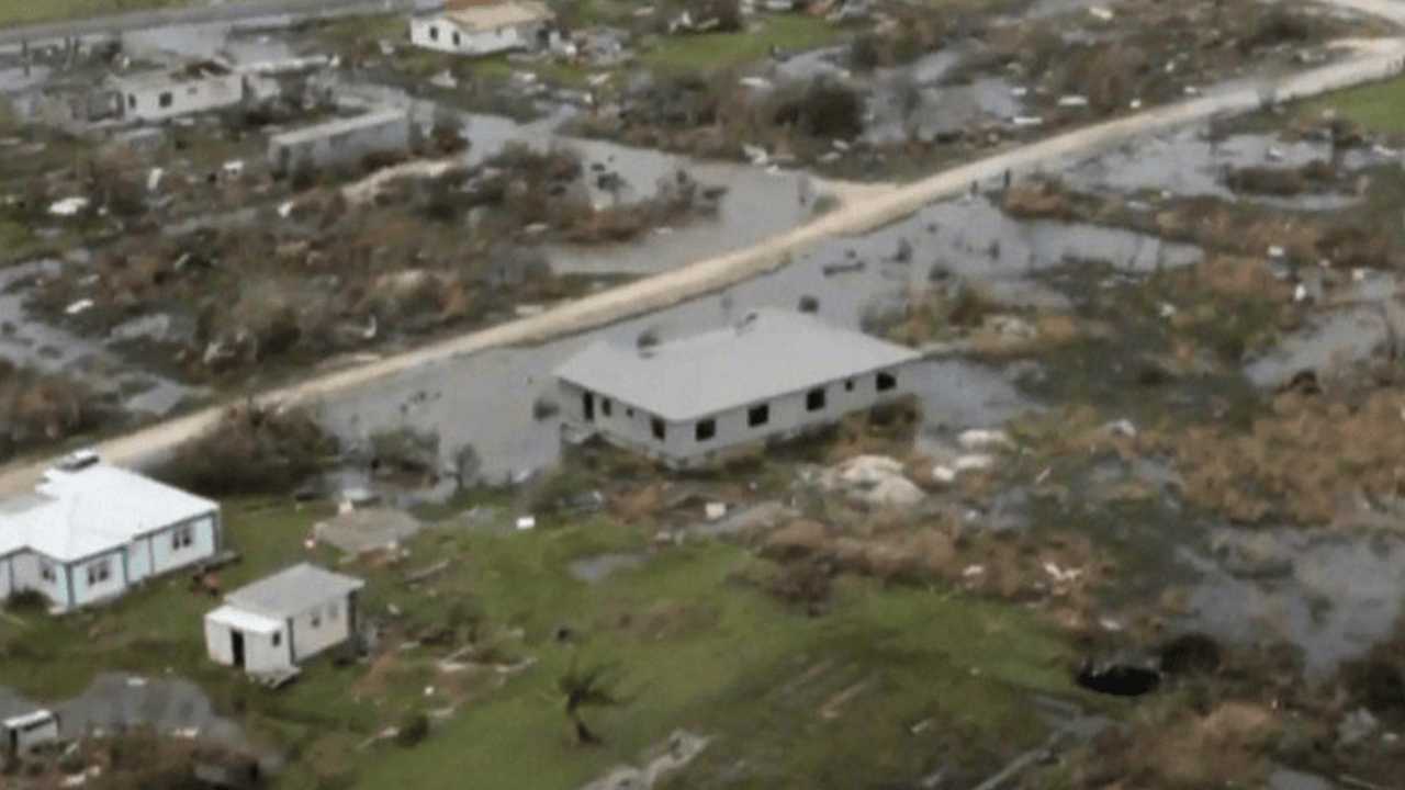
hou men hart al vast voor Haiti
ORiON
Legacy Member
Wat is altijd erg vind is dat de mensheid toch wel heel hardleers is.
Want men blijft gebrekkige gebouwen neerpoten op deze eilanden desondanks de voorgeschiedenis.
En alsook climate change en de negationisten hierover. Tropische cyclonen zijn direct verbonden met de temperatuur van het zeewater (is hun brandstof). Waarom blijft men dan overal rondbazuinen dat er geen directe correlatie te vinden is?
We moeten een kat een kat noemen en vooruit in deze wereld. Elk jaar halen we onze pleisters boven en patchen we een eilandje op.
Want men blijft gebrekkige gebouwen neerpoten op deze eilanden desondanks de voorgeschiedenis.
Atlantic hurricanes typically propagate around the periphery of the subtropical ridge, riding along its strongest winds. If the high is positioned to the east, then hurricanes generally propagate northeastward around the high’s western edge into the open Atlantic Ocean without making landfall. However, if the high is positioned to the west and extends far enough to the south, storms are blocked from curving north and forced to continue west, putting a large bulls-eye on Florida, Cuba, and the Gulf of Mexico, as was the case during much of the 2004 and 2005 Atlantic hurricane seasons.
En alsook climate change en de negationisten hierover. Tropische cyclonen zijn direct verbonden met de temperatuur van het zeewater (is hun brandstof). Waarom blijft men dan overal rondbazuinen dat er geen directe correlatie te vinden is?
We moeten een kat een kat noemen en vooruit in deze wereld. Elk jaar halen we onze pleisters boven en patchen we een eilandje op.
Lakigigar
Legacy Member
Trouwens ik heb in een onderzoek gelezen dat klimaatverandering ervoor zorgt dat het azorenhogedrukgebied merkwaardig krachtiger geworden is en ook westwaarts verschuift gemiddeld gezien.
Dat zorgt voor twee dingen:
- meer positieve nao, kouder klimaat groenland, milder klimaat europa en meer (zuid)-westenwinden.
- orkanen die een betere omgeving krijgen qua schering om snel te ontwikkelen (boven het al warme zeewater), en een sterkere ridge/rug ten noorden die ervoor zorgt dat ze minder snel naar het noorden afbuigen, en vaker trajecten riching het westen kiezen (met meer land), is een trend die vaker plaatsvond gedurende warme holoceenperiodes.
Proxy records based on paleotempestological research have revealed that major hurricane activity along the Gulf of Mexico coast varies on timescales of centuries to millennia. Few major hurricanes struck the Gulf coast during 3000–1400 BC and again during the most recent millennium. These quiescent intervals were separated by a hyperactive period during 1400 BC and 1000 AD, when the Gulf coast was struck frequently by catastrophic hurricanes and their landfall probabilities increased by 3–5 times. This millennial-scale variability has been attributed to long-term shifts in the position of the Azores High, which may also be linked to changes in the strength of the North Atlantic Oscillation.
According to the Azores High hypothesis, an anti-phase pattern is expected to exist between the Gulf of Mexico coast and the Atlantic coast. During the quiescent periods, a more northeasterly position of the Azores High would result in more hurricanes being steered towards the Atlantic coast. During the hyperactive period, more hurricanes were steered towards the Gulf coast as the Azores High was shifted to a more southwesterly position near the Caribbean. Such a displacement of the Azores High is consistent with paleoclimatic evidence that shows an abrupt onset of a drier climate in Haiti around 3200 14C years BP, and a change towards more humid conditions in the Great Plains during the late-Holocene as more moisture was pumped up the Mississippi Valley through the Gulf coast. Preliminary data from the northern Atlantic coast seem to support the Azores High hypothesis. A 3000-year proxy record from a coastal lake in Cape Cod suggests that hurricane activity increased significantly during the past 500–1000 years, just as the Gulf coast was amid a quiescent period of the last millennium.
Research into global warming suggests that it may be intensifying the Bermuda High in some years, independently of oscillations such as ENSO, leading to more precipitation extremes across the Southeastern United States. Latitudinal displacement of the ridge is also occurring, and computer models depict more westward expansion of the anticyclone in the future. However, during the winter of 2009–2010, the Azores High was smaller, displaced to the northeast and weaker than usual, allowing sea surface temperatures in the Central Atlantic to increase quickly.
Lakigigar
Legacy Member

Tracks of all known Atlantic tropical cyclones from 1851 to 2012.
Hier zie je dat mooi. Orkanen ontstaan tussen 10 graden en 30/35 graden noorderbreedte (bij de atlantische oceaan). Dichter bij de evenaar is de corioliskracht te hevig om ze te doen ontstaan, meer naar het noorden is het water niet warm genoeg, te veel schering en bij afrika ook veel te droge lucht (woestijngordel). De orkanen hebben de neiging naar het noorden uit te wijken door de corioliskracht maar bij een sterke rug gebeurt dit niet of minimaal en pas veel later wanneer de rug zwakker wordt. Dat is ook de reden waarom wij niet tot heel zelden met orkanen of tropische stormen te maken krijgen, al sluit ik niet uit dat er ooit een paar tropische stormen of een orkaan Ierland, Portugal, Het NW van spanje of Frankrijk kan bereiken, of er een zou kunnen ontstaan in de middelandse zee (al heb ik daar te weinig kennis over).
Een krachtigere azoor of bermudahoog betekent dat die westelijk aan invloed wint doordat de rug daar aan invloed wint, en de orkanen vaker westelijke trajecten kiezen richting de caribbean, mexico en de golf van mexico en ook florida. Het klimaat zou er ook vochtiger worden (de tropische gordel schuift noordwaarts) en zal de condities doen terugderen die doen denken aan de hoogtepunten van het mayarijk (het mayarijk viel uiteindelijk door een serie v. droogtes en klimaatverandering) en ook het romeinse rijk nog eerder. Het klimaat uit de 20ste eeuw is/was kouder dan die uit de tijd van de Romeinen, maar dat hangt ook samen met zonne-activeit enzo (en bij mexico ook de pdo die grote abnormale afwijkingen toont in die tijd bij historische reconstructies en nu meer schommelingen/cyclussen toonde. Bij de enso wordt bijvoorbeeld ook gevreesd voor een permanente el nino door klimaatverandering.
Uiteindelijk zal het zeer ingewikkeld beginnen worden want het lijkt dat de zon in een zeer langdurige en inactieve periode komt, en ik ben eigenlijk echt benieuwd hoe de gevolgen van "onze klimaatverandering" zich zullen verenigen met die problematiek/gevolgen. Twee factoren die het klimaat die we kennen volledig maar dan ook volledig zullen omgooien. We are playing with dark powers.
Het archief is een bevroren moment uit een vorige versie van dit forum, met andere regels en andere bazen. Deze posts weerspiegelen op geen enkele manier onze huidige ideeën, waarden of wereldbeelden en zijn op sommige plaatsen gecensureerd wegens ontoelaatbaar. Veel zijn in een andere tijdsgeest gemaakt, al dan niet ironisch - zoals in het ironische subforum Off-Topic - en zouden op dit moment niet meer gepost (mogen) worden. Toch bieden we dit archief nog graag aan als informatiedatabank en naslagwerk. Lees er hier meer over of start een gesprek met anderen.